Robots enlisted to survey Fukushima
24 June 2013
More robots are being put to work to survey the environment within the damaged reactor buildings of the Fukushima Daiichi plant and to map contamination in the surrounding lakes and rivers.
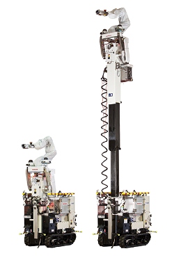
On 18 June, Tokyo Electric Power Company (Tepco) began using a "high-access survey robot" to survey the lower floors of the reactor building of unit 2 at the plant.
 |
| The high-area accessible crawler work platform was developed by AIST, while Honda developed the survey-performing robot arm installed on it, applying some of the technologies originally developed for its humanoid robot, ASIMO (Image: Honda) |
The robot was specifically developed for the task by Honda Motor Co and Japan's Institute of Advanced Industrial Science and Technology (AIST).
The crawler work platform - measuring 1.8 metres by 0.8 metres and weighing some 1100 kilograms - can travel at speeds up to 2 kilometres per hour. It has a height of 1.8 metres while being transported or travelling, but the 1.7-metre robot arm can extend up to seven metres.
Honda said that the robot arm "can easily approach hard-to-see objects that are behind other objects in a structurally-complex environment in the reactor building by applying simultaneous control on multiple joints." The robot employs a zoom camera, laser range finder and dosimeter at the tip of the arm to create detailed images, collect 3D data and identify sources of radiation.
Tepco said that the information gathered through the use of the robot will be used for the future planning of decontamination and restoration works.
The robot is the latest of a series to be developed specifically for clean-up and surveillance work at Fukushima Daiichi. Others have been developed by such companies as Mitsubishi Heavy Industries, Toshiba and Hitachi.
Submarine
 |
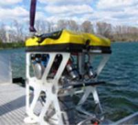
| The mini sub for measuring water contamination (Image: Areva) |
A remotely operated mini submarine developed by France's Areva has recently been delivered to Japan.
The sub carries a probe and takes readings underwater so that a map of contamination can be drawn up.
Teams from the Japan Atomic Energy Agency (JAEA) are being trained to operate the submarine, after which it will be used to map the lakes, reservoirs and rivers within the 20 kilometre evacuation zone around Fukushima.
Researched and written
by World Nuclear News