Analysis from Japan's Nuclear Regulation Authority (NRA) has revealed the most contaminated areas in the Fukushima evacuation zone have reduced in size by three quarters over the last two years.
Data comes from a series of helicopter surveys carried out on four occasions across the two years that followed the March 2011 accident at Fukushima Daiichi. Instruments trained on the ground captured radiation readings which were combined with GPS locations and adjusted for altitude variation to create maps for comparison.
Most obvious from the sequence of maps is the progressive reduction in the size of the red portion, which represents high radiation dose rates of over 19.0 microSieverts per hour (uSv/h) - some 166 milliSieverts per year (mSv/y). These went from covering 27% of the 1113 square kilometer zone to just 6% between 5 November 2011 and 11 March 2013. All these higher activity areas are within towns and villages categorised as 'difficult to return to'.
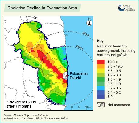 |
In the secondary 'no residence' zones there were never any locations above 19.0 uSv/h. In these areas the highest rates were on 6% of land that was above 9.5 uSv/h in the months after the accident, but these are now all gone. Today 70% of land has dose rates of less than 3.8 uSv/h.
Finally the less contaminated areas, described as 'preparing to lift the evacuation order', are now entirely below 3.8 uSv/h. This equates to a dose of 33.2 mSv/y, which remains higher but within reach of the proposed criteria of 20 mSv/y for return.
Apart from radioactive decay, natural processes have also contributed to reducing levels of contamination since the accident in March 2011. Rainfall moves contamination through river systems to the sea, where strong currents and a powerful dilution effect make radioactivity virtually undetectable even alongside the damaged power plant itself.
Researched and written
by World Nuclear News


_18570.jpg)
_16159.jpg)
_49205.jpg)
_18938.jpg)
